Exploring Furness
There is no mention of Furness in the Domesday Book, a great survey of England completed in 1086, but the recognisable settlements of Daltune, Ulurestun and Barey are listed in the sub-region of Amounderness. The area was dominated by Furness Abbey, founded in 1127. For centuries Furness remained the northern outpost of Lancashire, cut off from the rest of the county by the tides of Morecambe Bay yet connected by highways across the sands.
Walney
Walney is just under ten miles long and has experienced continuous settlement from at least the Neolithic period, about 6,000 years ago. Excavations of sand dunes on Walney uncovered hearths, rubbish heaps, pottery and tools. It is thought that Walney was the site for the polishing of much valued axes made of Langdale stone (which have been found widely distributed in England). There is evidence of Norse settlements from placenames: Earnse, Biggar and North Scale. Furness Abbey owned farmsteads at Biggar and the north and south ends of the island.
The deep anchorage round Barrow became docks for the shipbuilding industry which was eventually to convert an isolated agricultural island into a modern suburb linked to the rest of Barrow.
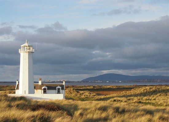
Walney can be reached by crossing the busy bridge or for a more scenic route you can cross near the Dock Museum, at a low tide, over the footbridge to North Scale. You can also walk round Walney (and maybe even see seals at the south end of the island). It is part of the national England Coast Path with a gorgeous 26km or 16 mile route through varied and stunning landscapes. Both the north end and south end of the island are nature reserves. North Walney National Nature Reserve is one of the best coastal nature reserves in the country, retaining a real wilderness feel with stunning mountain and sea views. It is one of the homes of the rare Natterjack toad. South Walney nature reserve has stunning views across Morecambe Bay and is great place for bird watching.
Rampside, Roa and Piel Island
It is likely that the network of islands and sheltered channels round the southern end of Furness were well-known to such experienced sailors as the Norse. A rare Viking burial was found in Rampside churchyard in 1909 (with the sword buried in the grave). And the Furness Hoard, a late Viking stash of ingots and coins, was found about 6km away at Stainton. All the names in this vicinity: Roa, Foulney, Futheray (Piel) are Norse.
Rampside was part of Furness Abbey's extensive lands in the medieval period but only after a land swop. Michael le Fleming and the abbot of Furness met in the middle of the twelfth century to neaten their boundaries. Urswick was exchanged by Furness Abbey for le Feming's Rampside and the dividing line, Shearer Beck (now Sarah Beck) is still used 850 years later as a boundary marker for Barrow-in-Furness Borough Council.
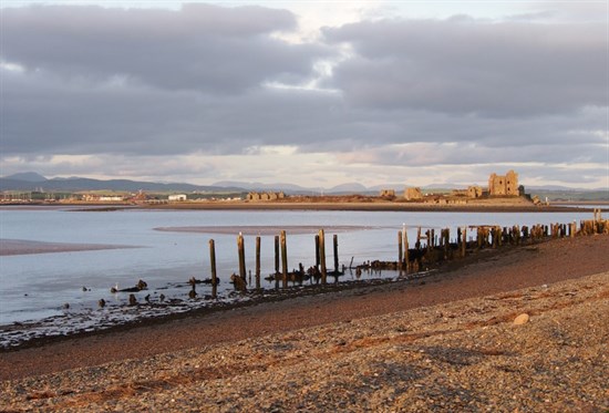
Piel Island's safe harbour and deep basin might have been a Roman signal station or, later, a Norse guide point for coastal shipping. There is no evidence but it's highly plausible. Today the ruins of Piel Castle are clearly visible and again tell the story of the might of Furness Abbey. The Abbey's ships had to be loaded and unloaded by small boats. This required speed and a fortified warehouse. It was the stage for an event of national importance when Lambert Simnel landed in 1487, intending to seize the English throne. The landlord of the inn on Piel, the Ship Inn, is known as the King of the island. He has a throne made from a single piece of oak, possibly from the castle or a shipwreck and the King can make "Knights of Piel".
The Westfield Greenway is a scenic walk (7km or 4.5 miles) for all the family from the Foulney Island car park to Cavendish Dock.
Ireleth
Ireleth is clustered on the hillside overlooking the flat sands of the Duddon Estuary. The settlement is listed in the 11th Century Domesday Book, though for modern eyes it is difficult to spot, appearing as “Gerleuuorde”. Furness Abbey established a grange (farmstead) at Ireleth.
One of the routes out of Furness was from Ireleth, over the treacherous sands. There was also a safer land route, becoming a turnpike road from Ireleth to Kendal via Lindal, Ulverston, Bouth and Newby Bridge. When the Furness Railway eventually connected itself to the national network with the building of the Kent, Leven and Duddon viaducts, the sea barrier was finally defeated, although Furness remained a branch line.

Askam
Askam was established following the discovery of a large quantities of iron ore. In 1864 the Furness Iron and Steel Company was set up to smelt iron at Askam. The site of the new works and village was called Ireleth Marsh. The Ironworks were situated on a former rabbit warren. After a few years the Company was bought out by the Askam and Mouzell Iron Company but the intended expansion of Askam never happened. The Ironworks kept going until 1919, but never threatened to lift Askam out of its stalled development. Today there are reminders of the town's industrial heritage from street names such as Steel Street and Askam Pier (pictured) which is made from slag (waste) from the old iron works.